ImageSat International, an operator of advanced imagery satellites who specializes in satellite data extraction and analysis, has recently released a detailed report, in which it estimates that the Libyan oil market can recover and return to full-scale production within a few months.
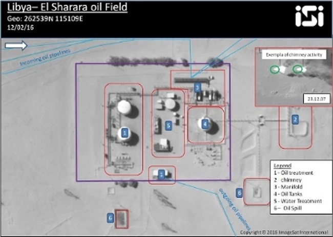
This assessment is based on the analysis of updated satellite imagery of key sites in the Libyan oil apparatus, which revealed that only a small number of sites, especially those adjacent to Islamist terror organization hubs, were targeted and damaged. However, apart from those few, as determined by company experts in the report, the majority of the oil related sites are well maintained and will be ready for full-scale production in a short time. The report stresses, for example, the fact that the sites located in Western Libya, such as "Elephant" and "El Shahara", which have a key role in the state's oil production capability, seem to be in good shape.
"It is true," stated ImageSat CEO, Mr. Noam Segal, "that many attacks target oil facilities, however these are mostly on few non-active facilities. The others seem to be well maintained and will be ready for renewed operation in no more than a few months." The implication of this information is that the main factor that hinders Libya from returning to its status as a key player in the turbulent global oil market, is the state's political condition and not necessarily terrorist activity. The importance of this report, as noted by the company, is that only up-to-date data extracted from high-end, high-resolution satellite imagery, paired with advanced imagery analysis capabilities, can truly indicate the physical state of extensive infrastructure facilities, while offsetting the effect of ground-photographed data which allegedly depicts an extreme situation, however may not reflect the true condition.
ImageSat CEO added that the company has decided to expand its satellite imagery data analysis services capabilities to commercial markets, and experts and different international analysis groups have expressed their interest in using this ability to research other markets and regions in the world. "ImageSat combines leading satellite capabilities with a high end data analysis foundation for various needs and tasks." The CEO further noted that the company is a world leader in imagery analysis capabilities, calls additional consumers to challenge ImageSat experts with requests to produce situation reports on different regions and economic areas.
About ImageSat International (ISI)
ImageSat International is a global leader in end-to-end geospatial solutions, owner and operator of very high resolution EROS satellites.
Harnessing satellite imagery, processing tools and experienced team of analysts, ISI integrates pixel-level geospatial information with open source research, to conduct viable data analysis and gain actionable insights, to better understand and act upon geo-political, environmental and economic realities.


 English
  العربية


